The Walchensee
- is one of the few, still untouched mountain lakes in the Bavarian Alps,
- whose shore is freely accessible everywhere.
- Protected Landscape Area
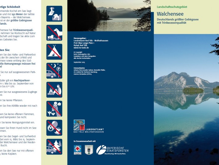
- largest mountain lake in Germany
- deepest alpine lake in Bavaria
- has drinking water quality
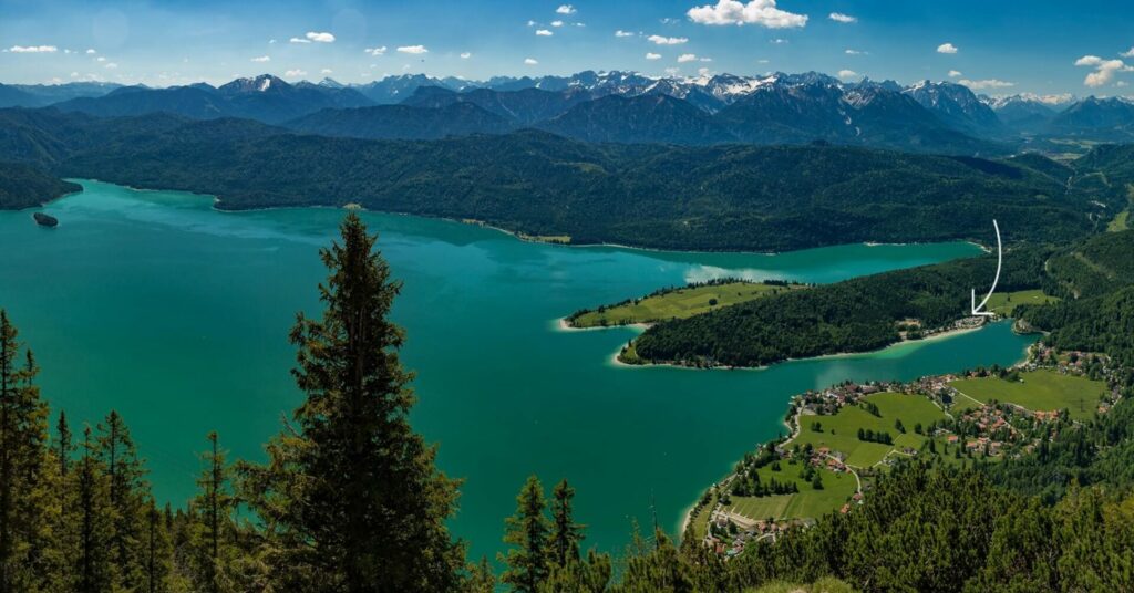
- is 7 km long and 5 km wide
- a water surface of 16,4 km²
- lies at 803 m NN and r
- almost 200 m deep (i.e. almost down to the 600 m high Kochelsee).
- has an average water temperature in summer of 18-21°C.
- Since 1925 also serves as a balancing reservoir of the power plant of the same name
Walchensee is one of the deepest (maximum depth: 190 m)[4] and at the same time one of the largest (16.40 km²) alpine lakes in Germany. It is located 75 km south of Munich in the Bavarian Prealps, at 800 m above sea level and with its entire area including the island of Sassau in the municipality of Kochel am See. To the east and south, its banks border the community of Jachenau. The landowner of the lake and island area is the Bavarian State (administered by the Bavarian State Forests[5][6] unlike most of the other larger lakes in Bavaria, which are under the administration of the State Palaces, Gardens and Lakes).
Originally a natural lake, it has served since 1924 as a water reservoir for the Walchensee power plant, which is located 200 meters below at Kochelsee. Source Wikipedia
Geology
The mountains surrounding Walchensee (up to 1840 m NN) belong to the Bavarian Limestone Alps and consist mainly of Triassic rocks and Quaternary sediments. In addition, there are also isolated foreign rocks (erratic blocks), which were delivered here by the glaciers of the Ice Age from the Central Alps. The Walchensee mountains border almost seamlessly on the Loisachtal valley in the west and extensive moorlands in the north (Murnauer Moos, Kochelsee-Moore).
Today’s landscape is mainly characterized by glacial erosion during the ice ages. However, the lake is not only a creation of the ice-age glaciers, which undoubtedly reshaped it, but was already present earlier as a tectonic depression (i.e. from the time of the Alpine mountain building), which is also indicated by its great depth.
Climate
The blossoming of apple trees (beginning of spring) starts relatively late in the Walchensee area (after 20.5.), the temperatures are in the long-term average about 10°C in July or -4°C to -6°C in January.The temperature differences between day and night are large, between summer and winter very large.
Ground fog formations are extremely rare throughout the year; the number of clear days is more than 50 days per year. A special feature are the downdrafts coming from Herzogstand and Jochberg, which blow „reliably from noon to early evening barely below force four“ over the lake.
Another phenomenon is the frequent occurrence of the foehn. Foehn days are characterized by deep blue skies and high feathery or streaky cloud cover. When the foehn is blowing, the sky is so clear that you can see all the way to Munich from the Herzogstand.
Flora
According to the Species and Biotope Protection Program, more than 41 plant species of the „Red List of Bavaria“ and more than 44 species of the „Red List of the FRG“ have been identified in the Walchensee area.
Important are e.g. the occurrences of numerous gentian species, daphne, alpine anemone, snow heath, alpine thistle, silver thistle, club moss, yew and juniper.
In the lower regions, a mixed forest prevails. The tree line is
at about 1700 m.
Sassau Island is designated as a natural forest reserve and a nature reserve. Due to a ban on trespassing, many plants that used to be found around Walchensee thrive on the island today.
Fauna
Until the end of the 15th century there were only pike, trout and perch in Walchensee. In 1480 whitefish were used for the first time and char in 1503.
The lake, its shores and Sassau Island represent a valuable breeding area for waterfowl; the wide expanse of water serves as an important passage and wintering habitat for diving ducks.
In the forests live numerous red deer; also chamois herds are still to be found. The rocky summit regions are home to the capercaillie, the black grouse, the mountain hare and the ptarmigan. Let’s not forget the alpine jackdaw, which is very common everywhere.
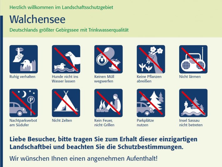
We therefore ask you:
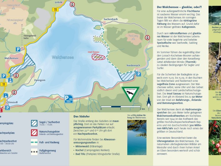
- Observe the stopping and parking ban along the B11 between Urfeld and Walchensee and along the south shore. All escape routes must remain clear.
- Park only in designated parking areas.
- Do not camp or spend the night outdoors.
- Take your waste back home with you.
- Do not light open flames and do not grill.
- Do not let your dog swim in the lake
- The road along the south bank is subject to tolls. There, parking is allowed only in designated parking spaces.
- Between 22:00 and 06:00 there is a night parking ban on the whole lake.
- Do not enter the western shore between Urfeld and Walchensee outside of designated access points.
- Do not store your boat outside boat moorings for more than one day.
- For the safety of bathers is always from 15.3. until 15.9. designated a sailing and surfing-free zone in the bays near Walchensee and Niedernach.
- Only navigate the lake in open boats, no cabins.
- Do not bring cleaning products into the lake.
- The island of Sassau is a nature reserve. There is a prohibition of navigation, landing and entering at a distance of up to 50 meters from the island.
Please be considerate of nature & landscape and actively contribute to the protection of the area!
Sources:
District Office Bad Tölz-Wolfratshausen:
Field 31: Water and soil
Field 35: Environment, Lower Nature Conservation Authority